Experience from Landslide Monitoring in Rwanda
The technology is not limited to laboratory testing or theoretical applications.
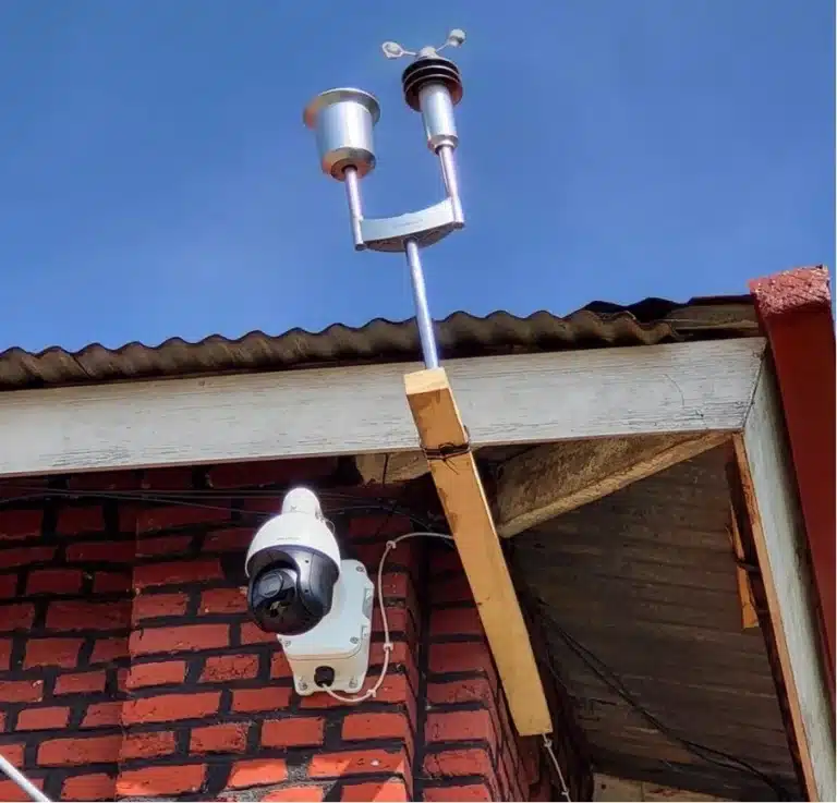
An important example comes from Rambura in Rwanda, where Hesotech’s iMaster/DocuCam technology was used in a landslide-monitoring project involving the Rwanda Space Agency and the country’s disaster-management authorities, with support from GIZ.
The project is described in the 2025 peer-reviewed scientific publication Application of geospatial and ICT technologies for landslide disaster risk reduction in Rwanda, published in Progress in Disaster Science.
The monitoring system combined high-resolution camera images with weather observations. Computer vision techniques were used to analyse changes in the landscape, including changes in surface conditions associated with landslide activity.
The work showed how repeated visual observations can help identify and document developments that may otherwise be difficult to assess through individual measurements alone.
It also demonstrated how this information can be collected, analysed and made available within a common monitoring environment.
The distinction between landslide and flood monitoring is important. The Rwanda project provides practical evidence for the application of automated visual monitoring to landslide risks. It does not mean that the same algorithms can simply be transferred to rivers or flood-prone areas.
Different hazards require different monitoring methods and warning criteria. Nevertheless, the underlying principle of combining visual observations, measurements and automated analysis has clear relevance for other environmental applications.
Opportunities for Flood and Water Management
For WaveSave, the partnership opens up opportunities to incorporate visual monitoring into projects where traditional sensor networks would benefit from additional information.
Along rivers and waterways, cameras could be used to observe changing conditions around bridges, embankments, drainage structures and other vulnerable locations. Combined with rainfall and water-level measurements, these observations can help provide a more complete picture of what is happening.
There are also opportunities around reservoirs, retention areas and flood protection infrastructure, where visual records can support remote assessment and provide a useful history of changing conditions.
In mountainous catchments, the technology may be particularly relevant where landslides, debris flows and flooding are closely connected. Changes in the surrounding terrain can affect waterways and infrastructure, sometimes creating additional risks further downstream.
For municipalities and water authorities, such information can support day-to-day monitoring as well as assessments during extreme weather events. Infrastructure operators may use it to observe critical locations, while disaster-management organisations can benefit from access to visual information alongside conventional warnings.
International development projects are another area of interest, particularly where monitoring solutions need to be developed in cooperation with local authorities and maintained over the longer term.
These applications will always depend on the conditions at a specific location. Camera positioning, visibility, connectivity, available measurements and the type of changes that need to be detected all influence the design of a monitoring system.
Combining Hesotech’s Technology with WaveSave’s Experience
The two companies bring different, but closely related, expertise to the partnership.
Hesotech has a background in automation, measurement and visualisation technology. Its iMaster/DocuCam platform provides the technical foundation for systematic camera monitoring, automated image interpretation and the management of associated measurements and events.
WaveSave works on practical solutions for water and climate-related challenges, including flood protection, monitoring, modelling and project implementation.
By working together, the companies can develop monitoring approaches that take account of both the technology and the circumstances in which it will be used.
For a water authority, that may mean combining visual observations with an existing sensor network. For a municipality, it could involve identifying vulnerable locations and establishing how warnings should reach the responsible teams. In an international development project, local capacity, maintenance and access to monitoring information may be equally important.
The objective is not to introduce technology for its own sake, but to make monitoring information more useful for the organisations working with it.


 Partnership
 Omar Saleh
 2026
2026 Reading time: 3 min